Rights of way (public paths)
You can walk on all public rights of way. Some are also open to horse riders, cyclists or motorists.
- Obstructions on public rights of way: hedges trees and shrubs [PDF]
- Ploughing and cropping information and guidance for landowners [PDF]
- Agricultural charter and rights of way [PDF]
Your rights
The Countryside and Rights of Way Act 2000 gave people more freedom to walk on open countryside. This applies to open access land, which has been opened to the public for walking.
On a right of way you can:
- walk dogs on a lead or under close control
- take a pushchair or wheelchair, although this can be difficult if the surface is uneven or muddy
- take a short route around an illegal obstruction (e.g. fences or crops) or move it to get past.
Types of path
There are four types of path and you can use different paths for different activities. They are signposted from the roadside, with markers along the route. You should always keep to the marked route.
| Arrow | Details |
|---|---|
 |
|
|
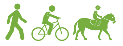
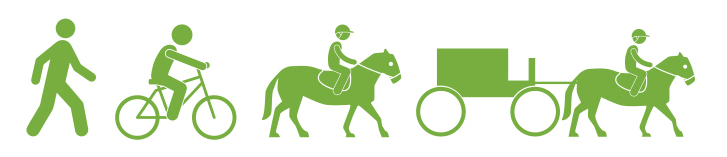
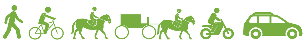
Footpaths are marked with yellow arrow. Only walkers can use footpaths |
|
 |
|
|
Bridleways are marked with blue arrows. Walkers, horse riders and cyclists can use bridleways. |
|
 |
|
|
Restricted byways are marked with burgundy arrows. Walkers, horse riders, cyclists and horse and cart users can use restricted byways. Cars and motorcycles are not allowed. |
|
 |
|
|
Byways are marked with red arrows. Walkers, horse riders, cyclists car users, motorcyclists and and horse and cart users can all use byways. |

Report problems and request information
Many paths go across or around fields that contain crops or have been ploughed and may be uneven or muddy. Public paths should be clear from obstruction and fences, gates and stiles must be in good condition, easy to open and unlocked.
Common Land and Town Village Greens
Commons and Village Greens
As the Registration Authority for Nottinghamshire, the County Council holds and maintains the official registers for Common Land and Town/Village Greens. There are currently 83 registered commons and 84 registered greens in Nottinghamshire. The registers hold information about the land and also contain maps showing the extent of the registered area. The registers can be inspected free of charge at County Hall by appointment.
Common land
In general terms, Common Land is defined as being land owned by one person, where another person (sometimes known as a ‘commoner’ or ‘right holder’) is entitled to exercise a ‘right’. Typically, rights of common involve the grazing of animals, taking wood, or cutting turf etc. In many cases these rights are no longer exercised however, this does not stop the land from being common land.
N.B. There are many areas of land named ‘commons’ which do not have the legal status of common land - the name alone is not a reliable way to identify a registered common.
Town or Village greens
Village Greens are areas of land where local people have historically indulged in lawful sports and pastimes.
This might include organised or informal games, picnics, fetes, dog walking or other similar activities.
A Village Green can be in private ownership but are usually owned and maintained by town and parish councils. Unlike common land there is no general right of public access over town or village greens, which instead is reserved for use by local people. The designation of ‘Town’ or ‘Village’ Green simply reflects the type of locality of the registered land.
In certain circumstances where land has been used for lawful sports and pastimes for a period of 20 years, an application can be made to formally register the land. Guidance on how to do this can be found on the GOV.UK website ‘Town and village greens: how to register’.
Open Access Land
The Countryside and Rights of Way Act 2000 (CRoW Act) gave the general public the right to roam on registered common land. An online map showing Open Access Land (including temporary restrictions) can be viewed on the Natural England website: ‘CRoW & Coastal Access Maps’.
Applications to correct the registers
The Commons Act 2006 contains provisions relevant to earlier commons and greens registrations. Although not all of the provisions of the 2006 Act currently apply in Nottinghamshire, it does mean that in certain circumstances the registers may be amended to deal with the following:
- Applications can be made to correct a mistake in the Common land and Town/Village Green Registers specifically where the mistake is shown to be attributable to the Registration Authority (per Section 19(2)(a) of the Commons Act 2006). These applications are free of charge.
- Where a mistake was shown to be made by a third party (e.g. a parish council), corrective applications can be made under paragraphs 6-9 of Schedule 2 of the 2006 Act to remove:
- buildings wrongly registered as common land
- other land wrongly registered as common land
- buildings wrongly registered as a town or village green
- other land wrongly registered as a town or village green
Nottinghamshire County Council has a set fee for applications made under paragraph 6-9. The application must be accompanied with evidence which shows that the property was wrongly registered. If objections are received to the application, additional fees may also be payable if the authority needs to seek external legal advice or if a hearing or public inquiry needs to be held.
Applicants are advised to seek their own legal advice before applying and must use Form CA10 (Common land and greens: correcting a mistake in the register) which is available on the GOV.UK website.
If you require further information, please contact: countryside.access@nottscc.gov.uk