Frequently asked questions
Find the answers to common questions about Colliery Way, formerly known as the Gedling Access Road. If you would like to ask any questions that are not covered in our FAQs or share feedback with us about the new road please email us using gar@viaem.co.uk or visit the Contact us page.
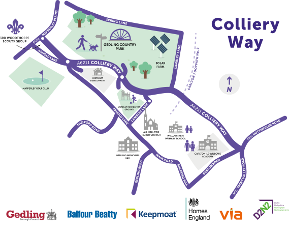
The wider road network opened to traffic on 15 July 2022. This included the realigned sections of Arnold Lane onto Colliery Way at the 5-arm roundabout. This has also included the upgrade and refurbishment of the existing Mapperley Plains / Gedling Road / Plains Road / Arnold Lane junction. Also, the following resurfacing has also taken place:
- Gedling Road (from Arnold Lane down to Whitby Crescent junction)
- Arnold Lane, on the approach to Mapperley Plains
- Plains Road from Arnold Lane to Appleton Gardens
- Resurfacing of the Mapperley Plains / Gedling Road / Plains Road / Arnold Lane junction
- Plains Road from Arnold Lane towards the junction with Westdale Lane West (done as part of the County Council’s latest approved three-year maintenance programme)
It is worth noting that due to planting seasons, road users may notice further landscaping works being undertaken in the Autumn. These will not affect the traffic network.
There are also some minor ongoing works to boundary treatments along Colliery Way. In addition, we are looking at some additional signage and lining along the route and wider network following feedback received from key stakeholders.
The existing junction was redesigned to work alongside the new Mapperley Plains / Colliery Way junction. The removal of the right turn at this location creates capacity and ensures that this junction operates efficiently. The two ahead lanes are maintained from previous road layouts and there is now a left turn lane for traffic turning onto Gedling Road.
A right turn lane is provided at the new Mapperley Plains / Colliery Way junction that is 150m further along.
It is not anticipated that this will be used very often as traffic from Gedling Village or from the A612 (via Colliery Way) wanting to turn right onto Mapperley Plains will likely use the Colliery Way link from the 5-arm roundabout to Mapperley Plains as in this case only one set of traffic lights will need to be used.
However, the right turn provides a safe and legal manoeuvre for residents of Bailey Drive, Swindell Close and Howieson Court who are unable to turn right from the access point directly off Plains Road (this is left turn only as before).
Also, for residents who live on the section of Mapperley Plains between Arnold Lane and Colliery then can use this right turn so that they are on the north side of Mapperley Plains making it easier to turn left directly into their properties rather than turning across traffic lanes from the opposite direction.
If I am travelling up Gedling Road from Arno Vale Road, how do I get onto Colliery Way?
It is anticipated that you will continue straight over the junction onto Arnold Lane as you did before. This links onto the 5-arm roundabout on Colliery Way. If you are local traffic for Gedling Village then you should use the roundabout and re-join Arnold Lane towards Gedling Village, all other traffic for the wider network towards the A612 and then either to Netherfield or Burton Joyce should continue along Colliery Way.
If I am travelling down Mapperley Plains towards the City, how do I get onto Colliery Way?
In this case you should turn left onto Colliery Way at the new junction, there is no need to continue on towards Arnold Lane as before. This links onto the 5-arm roundabout on Colliery Way. If you are local traffic for Gedling Village then you should use the roundabout and re-join Arnold Lane towards Gedling Village, all other traffic for the wider network towards the A612 and then either to Netherfield or Burton Joyce should continue along Colliery Way.
If I am travelling up Plains Road from the City, how do I get onto Colliery Way?
You should go straight over the traffic lights at the Arnold Lane / Gedling Road junction and then turn right onto Colliery Way - you can no longer turn right onto Arnold Lane as before. This links onto the 5-arm roundabout on Colliery Way. If you are local traffic for Gedling Village then you should use the roundabout and re-join Arnold Lane towards Gedling Village, all other traffic for the wider network towards the A612 and then either to Netherfield or Burton Joyce should continue along Colliery Way.
If I am travelling from Gedling Village towards Mapperley, should I use Arnold Lane or Colliery Way at the 5-arm roundabout?
It depends upon your destination, options could be:
- If you are going to Mapperley Top, use Arnold Lane and turn left at the traffic lights onto Plains Road.
- If you are going along Gedling Road toward Arno Vale Road, use Arnold Lane and go straight over at the traffic lights onto Gedling Road.
- If you are going along Mapperley Plains away from the City, use Colliery Way and turn right at the lights onto Mapperley Plains.
- If you live on the Bailey Drive, Swindell Close and Howieson Court, use Arnold Lane and either turn left directly from Arnold Lane or continue to junction, turn left onto Plains Road and then turn left into Bailey Drive.
If I am travelling from further afield from the A612 towards Mapperley should I use Arnold Lane or Colliery Way at the 5-arm roundabout?
It depends upon your destination, options could be:
- If you are going to Mapperley Top, use Arnold Lane and turn left at the traffic lights onto Plains Road (unless a HGV then you should continue along Colliery Way and turn left onto Mapperley Plains before continuing onto Plains Road).
- If you are going along Gedling Road toward Arno Vale Road, use Arnold Lane and go straight over at the traffic lights onto Gedling Road (unless a HGV then you should continue along Colliery Way and turn left onto Mapperley Plains before turning right onto Plains Road).
- If you are going along Mapperley Plains away from the City, use Colliery Way and turn right at the lights onto Mapperley Plains.
- If you live on the Bailey Drive, Swindell Close and Howieson Court, use Arnold Lane and either turn left directly from Arnold Lane or continue to junction, turn left onto Plains Road and then turn left into Bailey Drive.
The new junction that forms Colliery Way / Burton Road / Nottingham Road (Service Road) and Colliery Way / A612 was designed to work as a large single junction rather than two. When the original design was done it was based on traffic levels at the time (2019 figures), included traffic growth for 15 years and known or committed development in the area including the housing developments that are currently under construction. The junction is designed to accommodate all traffic forecast to be using the junction in 2034.
The design has always included a ‘No Right Turn’ order that legally prevents the right turn from Colliery Way into Burton Road. A key reason for this is to keep strategic traffic on Colliery Way and on the A612 Trent Valley Way towards Netherfield. Local traffic in the future will use local roads and it is expected that residents in Gedling Village will use Arnold Lane as they did previously when travelling from the Mapperley area. Due to the new environmental weight limit area, large vehicles (exceeding 7.5T) that previously used Arnold Lane / Shearing Hill as a through route to Netherfield and further afield now have to use Colliery Way and then onto the A612.
This removes such traffic from Gedling Village, which has been a long stated local request and one of the aims of the project.
If a right turn was introduced it would have a serious detrimental impact upon the operation of the signalled junction, creating delays for all other manoeuvres throughout the junction. Notably, it would create a delay for traffic wishing to travel up and down Colliery Way as the junction at the A612 would effectively be split into two independent sets of traffic lights rather than operating as one as it does currently.
There is also a risk that traffic would back up at peak time between the two sets of traffic lights, which would result in traffic queuing onto the A612 and traffic not clearing the exit from Burton Road. The introduction of these delays onto the strategic road network is contrary to usual priorities and would impact upon the NCT operated bus service between Southwell and Nottingham (and vice versa).
The traffic impact modelling demonstrated that a right turn option would double the delay through the junction by the design year of 2034, including a doubling of queues on Colliery Way.
Whilst Arnold Lane is closed a safe, suitable diversion route to Gedling Village is in place via Colliery Way, A612 and Colwick Loop Road. We understand that the diversion will add time and mileage onto people's journeys, but this is estimated at five minutes in normal traffic conditions and a distance of approximately two miles. It is accepted that local traffic that is not an HGV may turn off Colliery Way onto Lambley Lane towards Gedling Village. There is nothing stopping this manoeuvre, it is a decision that drivers should take depending on their destination.
Once Arnold Lane is open, it is anticipated that local traffic will exit Colliery Way at the five-arm roundabout and travel down into Gedling Village as it did previously.
It has been reported and observed that some motorists, having travelled down Colliery Way, are choosing to access Burton Road illegally by making the right turn or alternatively by re-approaching the junction having made a U Turn on the A612, or by using the residential service road opposite Burton Road. These actions are considered to be unsafe and cause an inconvenience to residents.
It is normal practice as part of any new major infrastructure that post scheme traffic flow monitoring is undertaken, usually for a period of 12 months following completion of the works, to enable traffic patterns to settle.
In the case of Colliery Way, completion of the whole project is Summer 2022. Whilst Colliery Way has been open to traffic from March, it is being used as a diversion route for Arnold Lane and these wider works are integral to the final road network and establishing traffic patterns. There are also a number of development sites that will continue throughout 2022 and beyond, such as the expansion of Carlton le Willows Academy with a new access off Burton Road (due to be open Autumn 2023), more than a hundred new dwellings on the Linden Grove development off Burton Road, plus the continued build-out of the Chase Farm development off Arnold Lane. All of these will impact traffic behaviours and patterns in the area.
The County Council has committed to monitoring traffic patterns in the area upon completion of the entire Colliery Way project. It will consider any amendments to the road layout in the local area based upon that evidence in light of altered traffic patterns.
There are no plans currently to remove these traffic lights. As part of the construction of Colliery Way, the Burton Road traffic signals linked to the original bus plug were kept in place and these were considered as part of wider traffic modelling at planning. The traffic signals act as form of traffic calming and make Burton Road a less desirable route. This supports the wider strategic objective linked to Colliery Way to encourage traffic (non-local) to use the A-road network.
These traffic lights were modified as part of enabling works for Colliery Way so that they would work with the new traffic signal junction. In free flow traffic conditions, the lights have an all red phase. As traffic approaches the lights change to green so shouldn’t hold any vehicles up if traffic levels are low, or only in one direction. There is a vehicle detector on the outbound exit from the lights (towards Burton Joyce), which will alter the signal timings if traffic builds up
Nottinghamshire County Council remains committed to monitoring traffic patterns in the area upon completion of the entire Colliery Way project and this includes the Burton Road traffic signals (bus plug). Currently, they will remain whilst traffic patterns establish, and further consideration will be given in due course as part of the post-scheme monitoring surveys. This will need to include consideration that as part of the wider strategic objectives traffic should not be encouraged to use Burton Road.
In the early phases of Colliery Way in 2020, Burton Road in Gedling was fully closed to through traffic for four months at its junction with the A612. The diversion route was signposted along the Colwick Loop Road, and to ensure that traffic did not use the more convenient Stoke Lane, an ANPR enforcement camera was installed to enforce the bus gate adjacent to Carlton Town football club. This bus gate was initially introduced when the A612 Gedling Major Integrated Transport Scheme was built and opened in 2007.
Nottinghamshire County Council approved camera enforcement at this site in March 2020. Anecdotal evidence prior to the introduction of the camera enforcement suggested that the bus gate was regularly contravened. The camera and additional signing have proved successful at reducing through traffic on Stoke Lane. The camera enforcement of the Stoke Lane bus gate will remain at the moment whilst traffic patterns are established and will be given further consideration as part of the post scheme monitoring surveys.
Colliery Way is not on a scheduled bus route and no bus stop infrastructure has been implemented as part of the project. However, it is public highway and a classified ‘A’ road so can be used for all vehicle types, including buses and coaches.
Nottingham City transport operate a range of scheduled services in the area:
- The 26, 26A services operate between Nottingham and Southwell. This travels along Burton Road using the bottom of Colliery Way before travelling along the A612 Nottingham Road.
- The 46, 47 services operate between Nottingham to Woodborough and Lambley via Gedling Country Park (Spring Lane).
- The 44, 44A services operate between Nottingham and Gedling. This route serves Gedling Village and links closely to the new Chase Farm Development (Keepmoat Homes).
Any decisions on future services will be commercially based and linked to bus passenger usage levels.
As part of the construction of Colliery Way, a link was built from the four-arm roundabout into the new development. This will join and link to the internal road network in the future. The internal road network that forms part of the housing development is still private and needs to go through the process for Nottinghamshire County Council to formally adopt it. The current timescales for this are not known.
Keepmoat Homes is planning to move its construction access off Colliery Way using the new link constructed. This will separate construction traffic from the new housing and will also further remove large construction vehicles from Gedling Village.
The new Colliery Way junction and altered junction at Arnold Lane have been designed to work together and take into account traffic levels, future traffic growth and housing development. We believe that the final junction arrangements will be an improvement in terms of capacity and journey time.
The changes to the junction will see a dedicated lane and traffic signal phasing for right turning traffic. The new single lane is considered sufficient as traffic that would have turned left down Arnold Lane towards Gedling Village is anticipated to have already turned down Colliery Way at the previous junction. The ahead lane gets more green time than other phases in the light sequence as it will run in conjunction with the ahead traffic in the opposite direction and then continue to be green alongside the right turners. This arrangement is used on other large junctions across Nottinghamshire and this is indicated by the stop line for the right turners being setback from the ahead lane.
Why are there are no safety cameras on Colliery Way?
As part of the National Safety Camera Scheme the Nottinghamshire Partnership has to demonstrate to the Department for Transport’s consultants that speed cameras will only be used where there is a history of fatal, and/or serious road casualties and speeding. Therefore, all proposed speed camera locations are required to meet the government’s accident criteria for fixed or mobile camera sites.
In addition to accidents, each potential location must also satisfy various speed and other site criteria. Speed cameras should only be used if there is no other appropriate engineering solution. For example, fixed cameras can only be considered at locations where there have been at least three fatal or serious collisions per kilometre in the last three calendar years and where at least 20% of drivers are exceeding the speed limit. As Colliery Way only opened in March 2022 there are no records of such tragic incidents.
Central Government have charged Nottinghamshire County Council with reducing accidents involving death and serious injury and this is where resources are targeted. This ensures that finite resources are used as effectively as possible in road injury accident reduction terms.
Will there be any other speed enforcement on Colliery Way?
Nottinghamshire Police can undertake law enforcement anywhere in the County at any time, including along Colliery Way.
Road Safety Audits have been completed as part of outline and detailed design of Colliery Way. A Stage Three Road Safety Audit will be carried out now Colliery Way is open to identify any problems arising.
The Road Safety Audit Team will examine the highway scheme during daylight and during the hours of darkness. The Audit will generally focus on items such as; alignment; visibility; junction layouts; non-motorised user provision; signs, lines, lighting; signal operation and how all users are using the new road layout.